


HOWALD CAMPING-CASCADE-ZUNDELKOPF-COL KREUZWEG et retour par la croix bleue

patrickbeyrath
User
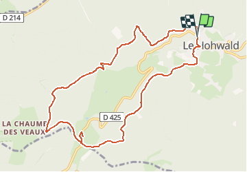

Length
10.3 km

Max alt
917 m

Uphill gradient
370 m
Km-Effort
15.2 km

Min alt
585 m

Downhill gradient
374 m
Boucle
Yes
Creation date :
2018-10-13 05:53:05.048
Updated on :
2018-10-13 05:53:05.063
3h16
Difficulty : Medium

FREE GPS app for hiking
 SityTrail
IGN / Geographical institutes
SityTrail Plus
The world is yours!
About
Trail Walking of 10.3 km to be discovered at Grand Est, Bas-Rhin, Le Hohwald. This trail is proposed by patrickbeyrath.
Positioning
Country:
France
Region :
Grand Est
Department/Province :
Bas-Rhin
Municipality :
Le Hohwald
Location:
Unknown
Start:(Dec)
Start:(UTM)
375900 ; 5362698 (32U) N.
Comments
Très sympa, principalement en forêt.